The Mitchell Map
The ‘Phantom Island’ of Isle Philippeaux in Lake Superior
In the Summer of 2023, Library and archive staff brought Univ’s copy of the ‘Mitchell Map’ out of storage and viewed it for the first time since 2009, when it had undergone some preservation work. The map, originally published in 1755, depicts large swathes of contemporary North America. Univ’s copy is believed to be the second edition, from around 1757. Now colloquially known as the Mitchell Map, its formal title is ‘a map of the British and French dominions in North America’, highlighting that the border disputes between European colonial powers are the focus.
Propaganda
John Mitchell was not himself a cartographer, but rather a botanist who was born and raised in Virginia. He and his wife moved to London in the 1740s due to ill health; after contracting malaria, the London weather was clearly deemed more suitable for recovery. It was here that he was commissioned to make the map by George Montagu Dunk, the second Earl of Halifax. The Earl was president of the Board of Trade and Plantations, a body intended to communicate with governors in the British colonies.
With the commissioner in mind, this was a map with an imperialist political agenda, created to show Britain’s stronghold in North America and to question that of France. At the time there were rising border tensions between British and French colonists, ahead of the Seven Years’ War. It seems that Halifax had an overt agenda; to garner support for defending British land interests/colonies from those of France and Spain, almost advocating military action over diplomacy. To this end, he gave Mitchell access to the archives of the Board as well as letters and surveys from colonial governors.
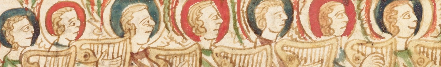
This was a map for a British audience, intended to show French encroachments onto British land, whilst laying claims to lands further westwards than the established colonies to the east. It was produced for a private market, evident from the high cost (at least a guinea) and its commercial production, from printer Andrew Millar. Nonetheless it seeks to show a stamp of government authority in a number of ways. Firstly, it contains a statement from John Pownall, the Secretary of the Plantation office, which reads that the map was ‘undertaken with the approbation and at the request of the Lords commissioners for trade and plantations’. Secondly, Mitchell’s own effusive dedication of the map in the elaborate (and problematic) cartouche, to his patron and the ‘lords commissioners for Trade and Plantations’. The inclusion of both of these written statements serve as an attempt to give extra clout and authority to the publication, making it official and definitive. As a further visual of the claim for the British Empire, the cartouche depicts indigenous people in deference to the Union flag. Once the map was created, Lord Hardwicke (Lord Chancellor at the time) asked for its publication to be supressed, with concerns that a wide distribution of an ‘officially sanctioned’ map might invoke anger amongst the general public if accommodations over borders could in fact be made.
Comprising of eight distinct sheets of paper, when pieced together the map measures 198cm x 142cm. Univ’s copy has all eight sheets bound together, with a backing of cloth. There is some evidence that Univ’s copy may have been displayed in its entirety; accompanying the map is a display pole, meaning it has probably hung on a wall at some point. The map was engraved (by Thomas Kitchin) on copper plates and then printed, originally with a hand colour wash and with geographical boundaries colour coded. Some colour is still visible.
The map shows incredible detail. There are many things you would expect to see on a map; a detailed key, a scale showing leagues and miles represented in different measurements according to country. There are uncharted locations including the extent and depth of the Mississippi River and a river in Florida ‘unknown to geographers’ . But underlying all the detail is an ongoing written political commentary. Areas of land inhabited by the Chicasaw are described as ‘in alliance and subjection to the English’ and ‘the country of the Cherakees [sic] which extends westward to the Mississippi and northward to the confines of the Six Nations was formally surrendered to the Crown of Britain at Westminster in 1729’. Mitchell was making a claim for both existing and future westward British dominions, creating a vision of Empire ahead of a war that would see France ceding territory to Britain and their presence in North America reduced.
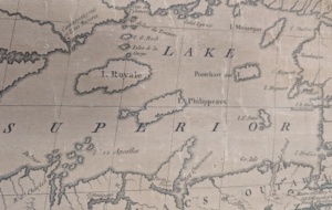
A ‘phantom island’
The map had influence beyond its patron’s immediate political goals. There is evidence that it was still being consulted decades later, most notably at the end of the American War of Independence. The map shows a number of islands in Lake Superior. However at least one of these, Isle Philippeaux, does not exist. Mitchell will have been working with older maps when creating his own, some of which list this particular island as being near to Isle Royale. It is a phantom island, but wasn’t discovered to be so until the 19th century. Its presence is significant, because when Mitchell’s map was used to draw up the Treaty of Paris some thirty years later, the island was listed to establish a border between Canada (then ‘British North America’) and the newly founded United States of America.
Its scale and rich detail make it an impressive piece of material culture; it was clearly designed to both persuade and impress. However, it is a ‘visionary’ map, in terms of it being a projection of empire that Halifax could visualise, rather than being geographically accurate. It remains a fascinating map which contributes to a colonial rhetoric, just thirty years before the map was used to help dismantle parts of the British Empire and create a new, independent nation.


References and further reading
Beaumont, Andrew D. M. “The Perfect Storm, 1753–54.” Colonial America and the Earl of Halifax, 1748-1761. United Kingdom: Oxford University Press, 2015.
Edelson, S. Max. The New Map of Empire : How Britain Imagined America before Independence. Cambridge, MA: Harvard University Press, 2017.
Edney, Matthew H. “A Publishing History of John Mitchell’s Map of North America, 1755-1775.” Cartographic perspectives 58 (2007): 4–27.
Edney, Matthew H. “John Mitchell’s Map of North America (1755): A Study of the Use and Publication of Official Maps in Eighteenth-Century Britain.” Imago mundi (Lympne) 60.1 (2008): 63–85.
Oxford Dictionary of National Biography entries for Mitchell, John (1711–1768) and Dunk, George Montagu, second earl of Halifax (1716–1771)